| BesidesWork |  |
Home / BesidesWork /
|
|
|
 |
| Adventure & Sports |
| Expedition Diary: Everest to Kanchenjunga And Kanchenjunga Circuit Expedition by Malli Mastan Babu, an NIT, IIT, IIM alum and an expert mountaineer |
| Author : | thedesk |
| Institute : | |
| Posting Date : | 12/09/08 |


|
|
|
| Total 29 vote(s). |  | |
|
|
|
|
|
A regularly updated live Expedition Diary by Malli Mastan Babu on the "First Ever" high altitude expedition from Everest region (Nepal) to Kanchenjunga traversing the high altitude passes and visiting the base camps of 5 of the first six tallest peaks of the world such as Everest 8850m, Kanchenjunga 8586m, Lhotse 8516m, Makalu 8463m, Cho Oyu 8201m and their glaciers en route.
|
|
|
I guess, you remember me telling you that I am attempting an expedition called "Kanchenjunga Circuit" which is high altitude circumnavigation of Kanchenjunga Massif.
I have extended my mission a bit further and now want to attempt a bigger Adventure:
Everest Region to Kanchenjunga traversing high altitude passes between 18000 - 21,000ft and visiting the base camps of 5 of the first Six tallest peaks in the world - Everest 8850m, Kanchenjunga 8586m, Lhotse 8516m, Cho Oyu 8201m. barring only K2 which is POK.
After doing Everest - Kanchenjunga, I would like to do the Round Kanchenjunga trek and then follow the singalila ridge bordering India nepal to arrive near Darjeeling.
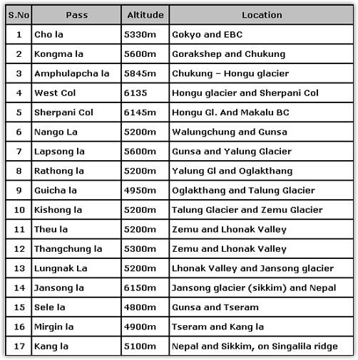
The total distance walked will be approx 1500km, and duration = 80days; and 17 high altitude passes (5000 - 6200m).
Please see below the details and maps of the expedition.
Everest to Kanchenjunga And Kanchenjunga Circuit Expedition
Mission:
To undertake "First Ever" high altitude expedition from Everest region (Nepal) to Kanchenjunga traversing the high altitude passes and visiting the base camps of 5 of the first six tallest peaks of the world such as Everest 8850m, Kanchenjunga 8586m, Lhotse 8516m, Makalu 8463m, Cho Oyu 8201m and their glaciers en route.
Dates: Sep 14 - Nov 30, 2008
Total Duration: 80days approx.;
Total Distance: 1500kms approx.;
Total Passes: 17 (Between 5000 - 6200m)
Malli Mastan Babu: Worlds Fastest 7 Summiter
I have achieved several International and national records in the field of Mountaineering and endurance events such as marathons. In 2006, I have climbed the tallest peak in each of the seven continents in a span of 172 days and set a world record; besides accomplishing several Indian records. In 2007, I undertook 900km of High altitude traverse of 4 Dhams (Yamunotri, Gangotri, Badrinath and Kedarnath) in the Garhwal Himalayas becoming the first ever to do so at one stretch. In later half 2007, I ran 14 half marathons in 14 states of in India in 14 days each day running 21.2km and flying to the next destination. I have also run 8 full marathons (42.2km) and 3 half marathons in 13 days in 10 different states of India.
Now I would like to embark on this epic Himalayan Adventure!
Everest - Kanchenjunga, and @Kanchenjunga Introduction:
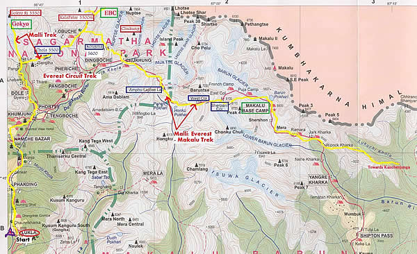
A Challenging route through high altitude passes and glaciers exists between Everest Kanchenjunga. The first part (18days) of the trek goes towards West of Everest leading to Cho Oyu 8201m, after Cho la 5330m crossing the route enters to Khumbhu valley, and then via Kongma la 5600m it leads to Chukung valley to the south of Lhotse Shar.
The second part of the expedition (10days), from Chukung Valley to Makalu Base exists another adventurous route through very high passes such as Amphulapcha 5845, West Col 6135m and Sherpani col 6145m. Between them lie Imja, Hongu, Barun and Makalu glaciers. Then the route from Makalu to Kanchenjunga follows a moderate altitude traverse through several nepali villages before reaching Gunsa at the foothills of Kanchenjunga, Nepal.
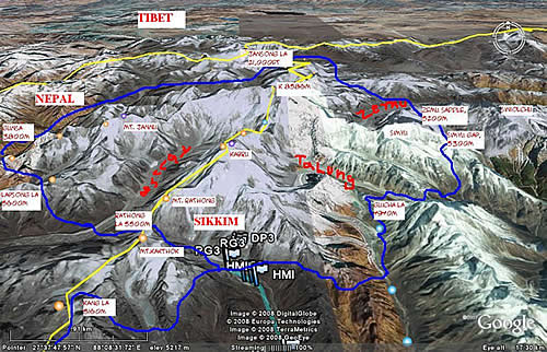
Next part of the expedition goes round Kanchenjunga massif, negotiating the glaciers and traversing the high passes as close to the mountain as possible. Such an attempt was made only thrice in the history (1884, 1898, 930) till now. The route that I designed is very new and more challenging than the earlier ones. After circumnavigation of Kanchenjunga massif the route follows the Singalila ridge from Kanchenjunga and terminates at Sandakphu, 12,000ft a village bordering India and Nepal which offers best views of Everest, Makalu and Kanchenjunga.
Route Description:
Begin Expedition: India - Kathmandu (Fly) ; Kathmandu - lukla (fly)
Part 1 (18 days): Everest Circuit
Lukla - Namche - Gokyo; Mt. ChoOyu 8201m Base Camp
Gokyo - Chola5330m - Everest 8850m Base Camp
EBC - Lobuche - Kongma la 5600m- Chukung - Lhotse 8516m Base camp
Part 2 (20 days): a) Everest - Makalu Trek
Chukung - Amphu lapcha pass 5875m - West Col 6135m - Sherpani col 6145m - Makalu 8485m base camp
(Refer: Part1 map below)
b) Makalu - Kanchenjunga
Makalu base camp - Walungchong - Nango la - Gunsa (Kanchenjunga)
(Refer Part 2 map of attachment)
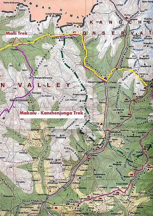
Part 3 (35days): Kanchenjunga Circuit
Sec: 7 days
Gunsa - Lapsong la - Yalung Gl. - Rathong la - Oklangthang. - Guicha la - Talung Gl.
Sec2: 10 days
Talung Gl. - Sakyong - Kishong la - Zemu Gl. - Theu la - Thangchung la - Upper Lhonak
Sec3: 7 days
Upper Lhonak - Goma chu - Jansong la 6150m - Pangpema - Gunsa
Part 4: 10 days; Kanchenjunga - Darjeeling; Singalila Ridge
Gunsa - Mirgin la - Kang la 5200m - Chewa bhanjang - Sandakphu - Tonglu - Darjeeling
(End of Expedition)
Total Number of High Passes Crossed:
Glaciers visited:
Around Everest
Ngozumpa (Cho Oyu), Khumbhu (Everest), Imja Glacier, Hongu Glacier, Barun, Makalu
Around Kanchejunga:
Yalung, Talung , Tongshyong, Simvu glacier, Zemu, Lhonak and Jansong, Kangchen,
Base Camps Visited:
Cho Oyu 5200m (South side, Nepal), Everest 5300m (Nepal), Pumori 5700m, Lhotse Shar 5100m, Islad peak 5300m, Barun Tse 5450m, Makalu 5200m, Kanchenjunga on all four sides.
*******
Update as on 8th September, 2008
Hi:
I am in Gangtok and in the final stages of planning & leaving for the trek:
Everest - Kanchenjunga - Singalila trek.
I will reach Delhi on 11th and fly for Kathmandu on 13th and resume Everest Trek along with an IIM C mate, He will come to India after trekking for 15 days and I would continue from there towards Kanchenjunga, the do round Kanchejunga and follow, Singalila ridge to arrive at Darjeeling. Then travel to Gangtok for some rest.
My latest plan/route:
Part1:
Lukla - Naamche - Thame - Renjo la 5380m - Gokyo - Cho la 5320m - Everest base camp - Kongma la 5600m - Chukung
Part2:
Chukung - Amphulapcha la 5845m - West Col 6135m - Sherpani col 6145m - Makalu base camp - Chepuwa - Thudam -Walungchung - Nango la 5200m - Gunsa
Part3: K Circuit
Gunsa - Lapsong la 5200m - Rathong la 5300m - Guicha la - Kishong la 5200m - Zemu - Theu la 5100m - Thanchung la 5200m - Jansong la 6200m - Pangpema - Gunsa
Part4:
Gunsa - Mirgin la - Sele la - Kang la 5200m - Chewabhanjyang - Sandakphu - Tonglu - Manebhanjyang - Darjeeling.
*******
Update as on 12th September, 2008
Hi:
I am in Delhi and making last minute preps to leave for Kathmandu and on 13th (12:55 jet airways) and will start the trek on 15th from lukla.
I am trying to procure a sat phone for communication but couldn't get one. I am willing to pay for it (costs abt 1200$ including talk time). I will be able to send the updates better with that.
anyways, I would like send one update today in the evening.
I was sharing my expedition preparation with Mr. George Band (1st Summiter of Kanchenjunga 1955, he was also the youngest member of 1953 Hillary Everest Expedition, a very accomplish authority in moutaineering); I will send those mail exchanges.
Mr. Norman Hardie another First summiters of Kanchenjunga (1955expedition) trekked from Kanchenjunga to Everest base camp after summiting Kanchenjunga in 1955. I exchanged mails with him as well.. He had taken a bit low altitude route to reach lukla while I am considering a bit high altitude route. I have high regards for him and my plan is based on his experience. I read his book "On my own two feet and got inspired to do the journey otherway. Some part of the trek will follow the same route; so I would want to collate how the region in two periods of time.
I will share more in later half of the day.
Photos: my photo on the summit of Carstensz pyramid, tallest of Oceania continent, 1st Indian; other (photos) mountains are in the everest region.

Mountains in the Everest Region
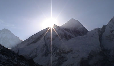
Mt. Everest view from Kalapatar Top 5550 mts.
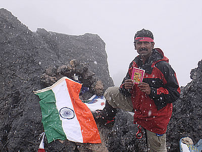
My photo on the summit of Carstensz pyramid, tallest peak of Oceania continent
Best Regards,
Malli
*******
Update as on 16th October, 2008
Hi,
Jounrney to Lukla 2800m: Gateway to Sagarmatha National Park:
I was in sikkim reading and planning for the Everest-Kanchenjunga-Singalila himalayan sojourn which would last for approximately 75 days and nearly 1500km. The route that i wanted to take kept evolving as i couldn't resisit the opportunity to visit the remote high passes and as well the beauty and the history that it beholds. Garnering the financial support was the next challenges besides I was simultaneously working for permits in Nepal/India and as well talking with Nepal agencies and sherpa friends to find suitable man power. My planning for this project went from April to almost August before I came to home (nellore) from Sikkim; Amidst this like a bright sunny day during the climbing periods, suddenly I heard from the officials that my name was nominated to be considered for "Tenzing Norgey National Adventure Award". I felt a little hopeful but was wary as usual. Pretty soon in a couple of days,the results were known and i wasn't selected; so the bad weatehr and the clouds gloomed over my life's journey. To some of the people in Indian mountaineering foundation and to the ministry of sports, "My 7 summits and other endurance (marathons) were not worthy achievements also it seems there's a big line of people who have already achieved. though under the aeigis of Army/institution. I remembered the words of wisdom from my sister that, " Babu, you have comeback safely from all the summits with success, consder that as the rewards and awards showered on you by the god!. Well, I guess that was very true. No award can match the happiness of standing on the summit and watching the surrounding views and the journey to reach that inhospitable place in solace. I shared this news with my friends Jay, Umar and Ulahs who consoled me saying, Malli: may be next time!
And then quickly i ignored 'Tenzing Award' and got busy with planning the expedition enthusiastically. In between I communicated with Fred (for Indiaseonline) and 6bridges.com for covering the expedition or article(not very clear communication howit goes etc). Mean while I got assurance from Jay that he will help me raise funds for me to go for the expedition. That's a very good news for me and I was very happy; Jay has helped me during my carstensz expedition to finish seven summits as well. Jay, Umar, Ulhas and Mr. Rajesh had given me more than half the expenses that i need for the expedition. Rest, I was spending on my own and my sister bought me the slr camera which I wanted to use for the expedition. Moreover I was ready to leave for the expedition.
Then there was another 'bright sunny day' in the climb, and I received a call from Sundeep (iim c senior, 2003) delhi amidst my afternoon nap that he spoke to samsung about me and samsung is very interested to sponsor for my expedition and as well may associate with me as brand ambassador in future and support for my future projects. So, Samsung sent a person from Delhi to shoot a film/interview etc to Nellore. This was about first week of september. Then i agreed to meet Samsung people in delhi before flying to Kathmandu. on 6th sept i started for Gangtok to pick up the climbing gear i left while in sikkim. By 10th sept. i was in delhi and those couple of days were hectic as i kept purchasing my last minute stuff (memory cards, batteries, maps, prinitouts etc) and shuttling between gurgaon and Nehru place, delhi. amidst this again delhi had it's own troubles of insurgency at cannaught place. i felt sad but was too much in my own tasks to leave for expedition.
I visited samsung office on 9th sept. and met the country head, vice president, media head and a few others. they were all very excited as usual, and after a few minutes of discussion and learning about the expenses, the country head and vice president went out of the room for a couple of minutes came back and announced that, straight away "Samsung is sponsoring 3.5 lacs half the expenses and as well pay me to purchase a sat phone. Well, i was very happy and excited.
I postponed a day of travel to kathmandu and next day, there was some more shooting with me and samsung logos on my jackets etc.. too good! I shared the news with my friends and sister: Obviously they were all very happy for me.
On 13th my sister and Sundeep (IIM C junior 2008,) arrived in Delhi to join me for about 12days to trek in the everest region. Sundeep was in touch with me for quite a long time, he was also involved actively in iim c with the adventure club that i started and as well did good amount of trekking. moreover he is from my home town. my sister got her visa+workpermit for UK and she would be leaving the country for 2years and so wanted to spend time with me and i had been working for the expedition since long time and so was difficult to postpone as the himalayan season would be over.
So, all three of us flew to Kathmandu with excitement on 13th afternoon and arrived by evening.
We put up overselves in Tamel in the same hotel i statyed when i had come to climb everest in 2006. The air of tamel, kathmandu and the expedition companies consumed my attention and i was very excited. with the assurance of Samsung sponsorship i wanted to purchase satphone and good solar panels for the expedition. i communicated with the "Thuraya outlet brach in kathmandu, the office was closed for the day and would open only at 10:30 am. Amidst this i was also planning for establishing sherpa support and logistics required for my sister and sundeep along the trek. i was as well seeking the help of "Everest Parivar Trek in acquring permits where ever required during the total expedition as i would be visiting everest region, Makalu - Barun National parks, and Kanchenjunga National park. Next day I visited the office of "Thuraya Sat phone" outlet and found out about the availability and price and recharge facilities. It's much costlier than in US. I called up Samsung people and informed. I was told to go ahead and purchase but i could sense some deliberation. I purchased the phone though with an element of doubt it being sponsored by samsung. I had as well bought a Nepal local mobile sim as i would be spending good amount of time in nepal trekking and mobile communications (connectivity) have reached much higher elevation even on everest trek.
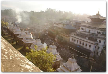
As the Funeral Pyres Rise at Pashupathi Temple, Kathmandu
Lukla 2800m
Sundeep, my sister and my self, all of us flew to Lukla by the first flight by Yeti airlines. While in Kathmandu i bought a few more maps and learnt about "Renzola 5350m" another less visited pass in Everest region. As soon as I landed in Lukla, greeted some of the earlier sherpa friends I knew and spoke to arrange for the sherpas. My sister was doing her first himalayan trek. She spent a few days in yuksom 1780m while I was there during April/May is all her himalayan experience if that can be considered as one. But I was determined to take on Renzola considering that it requires only long walking stamina.
We had our breakfast, hired two porters and started our trek towards Phakding by 10am. Sundeep and my sister were excited to be finally trekking and we spent quite amout oif time taking pictures and discussing/musing over the lives of the local denizens. As we walked along the path we met another group of Indians from Maharastra (Kolhapur). They wanted to visited Gokyo and do Cho la pass, an adventourous but more frequented by tourists in Everest region. we greeted them proceeded along our way. Phakding is at 2600m altitude and takes about 3hrs for average trekker. We had lunch there and proceeded towards Monjo for the days rest. Monjo is a good point to rest for the day as it makes the next day to "Namche" less strenuous. We camped at "Chomoa" 10minutes before Monjo. It had a good camping area. We had dinner in the tea house. The food is similar to Indian food though western food is also available. Sundeep and I slept in the tent.
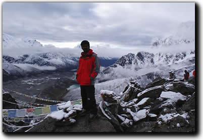
View from Gokyo Top
Next day, we registered at the Jorselle Check post where the official National park entrance exists. Then the route passed a few uphill and downhills before coming to the high suspension bridge before the namche hill. At this bridges the stream coming from Everest base camp and Cho oyu meet and henceforth called as "Dudh Khosi. From Jorselle to Namche it's a steep ascent of nearly 600m where most of the trekkers feel strenuous. It's a demanding climb up to a temporary stop amidst the climb. We took a rest of few minutes and had snacks here. After a few minutes the trail goes through dense pine forest which is very pleasing and beautiful. Its relief to see the houses of Namche as the path takes the undending last sinuous curve. My sister had a few health problems such as diarrhoea and was feeling weak. Inspite of this she was enjoying the trek and mostly tried not to disturb our schedule and make me feel comfortable. At Namche she was feeling very cold and i wondered but didn't think much consider it as her first himalayan trek. Next day of our jounrey was Thame. Thame is the village from where most of the famous Everest Summiters are from. The famous TenzingNorgey's parents migrated from Tibet to settle in Thame. He lived here before migrating to Darjeeling for earning his livelihood. Apa Sherpa, another famous Everest sherpa who summited Everest for maximum times also hails from here.
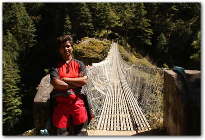
Hanging Bridges common along Ebc trek before Namche hill
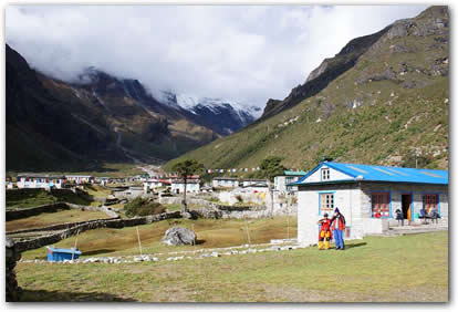
Thame 3800m from where most Everest sherpas hail
At thame, there's also an power generation project (Hydro project) that provides electricity for most of khumbhu region. The trail from Namche to Thame goes to west of Namche for about half an hour. From the hill top just above namche one gets a very beautiful view of Namche village. While coming to Namche, I called up Samsung people and found that the assured sponsorship was not transfered to my account and as well learnt that i would get the reimbursement for the sat phone I bought. I was told that, Samsung would talk to me after I comeback from the expedition regarding the future association. I thought, it was another bad weather after a bright sun during the climbing period.
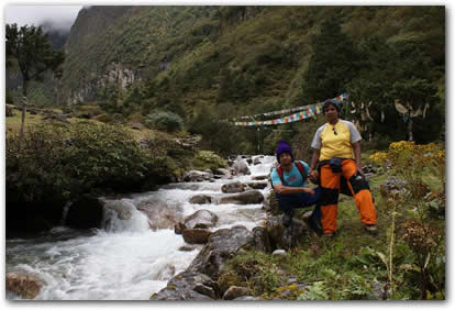
Beautiful waterstreams onway to Thame towards Renzola
The route Thame from Namche bazar was very beautiful. we saw some beautiful flowers, waterfalls and bridges built over huge gorges and the way water made shapes of rocks while cutting route through them. It took about 4hrs for us to reach here. My sister felt some headache but didn't really look very serious. May be she didn't reveal. We slept in the Apa Sherpa lodge. I was several of the "Guinness certificates framed and displayed in the hotel. We couldn't get good views of the himalayan peaks from here as it was cloudy. Next day morning clouds cleared and the skies revealed the beautiful peaks the gaurded the village to the west. we had early breakfast and headed for the next camp towards Marlung. my sister was slow but kept walking continuously.
We reached Marlung by about 11am and had small rest and tea. The terrain from Thame to Marlung is alpine zone and there was very less vegetation. After Marlung, my sister said that she wasn't feeling well but I thought, it may me usual altitude symptom and may subside as soon as we reach the next camp which is about 200m higher than Marlung. We walked for about 45minutes and climbed a small rasing hill and crossed the water stream coming from top, a few minutes after that, she started feeling breathless and gasping heavily and she felt as though her lungs would burst. That was a clear symptom of aggravating to "HAPE - High altitude Pulmonary Oedema, I acted immdetaitely. I caught her by hand and started dragging downhill towards Marlung. Porters were going ahead of us and sundeep was behind engrossed in enjoying the beauty of the place. I crossed Sundeep and told him to callback the porters. We descended to Marlung in five minutes. My sister regained her breath dramatically and started feeling better. The she had some garlic soup. She regained her breath but was feeling very cold. We draped her in sleeping bag and blankets. In another one hour she regained completely and was feeling better and was able to sit. I decided that we take rest for the day and wait for what to do next day whether go up towards Renzola or turn back towards Thame and to Namche.
*****
I would post the next message later. I have to leave for my next camp;
Yesterday, I chided my sherpas as there arrived very late to namche.
It's some kind of another management in action; We resolved the things and got focussed to achieve the objective/target.
We plan to reach Chukung tomorrow; then do Kongmala pass, Gorakshep, pumori base camp; then again come to chukung and attempt "Amphulapcha pass 5789m and sherpani col' both of which are considered to be very tricky.
I met some of my earlier climbing mates and as well some interesting people (who did fourteen 8000m peaks and 7 summits) attempting different peaks in the region. I met another person who was the first boy friend of Naina (Messner's girl friend who was there with Messner in 1980 when he summited everest solo, sans supplemental oxygen).
I have heard about a few deaths that happend while i was trekking in different region. That upsets but doesn't stops one's journey.
I heard about an Indian (Kolhapur tourist, whom we met in the beginning of the trek) who died at Chola pass while I was struggling to save my sister from the unfortunate happenning during my first part of Renzola trek.
Then after a couple of days of trek towards Mera la, I heard about the plane (yeti airlines) crash in Lukla and most of the people meet with unfateful event. Only one pilot could save his life while rest all perished. The airstrip was built by Sir Edmund Hillary in 1960's. He lost his wife and daughter in the plane crash at Lukla during those days. This is the next misfortunate one after that. Ironically "Yeti airlines' runs maximum flights and is most prefered among the tourists.
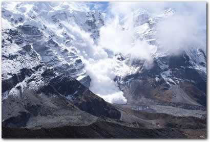
Avalanche at Khare 5000m Mera base camp
Yesterday, while i was waiting (for my sherpas to arrive) and having my food at a restaurant in the Namche bazar another tourist became a target of an irated yak passing by. It's as good as any street in one of the normal cities and he is passing by in a crowded street, suddenly this yak got pissed off and swung it's horns. He had the hit on upper thigh and toggled and got damaged over his nose, face and thighs.. bleeding.
Luckily, there was a doctors sitting nearby and immediately leaped to save him.. Several medical aides flew in and he was given first aid/treatment and then carried to the Khumjung/Khumde hospital.
During my treks, my thoughts travel to, why did I chose to do this long himalayan journey of 75days.. i am musing over this and it's a very good introspection towards life for me.. I could have invested these days for financial returns but didn't. I guess, it's a way of life that I chose and am happy here enjoying the nature and beauty. It may not yield me another financially even after many years.. but I would want to live the life the way I like.. During the trek, i get other thoughts such as what is the best way of one's live spent. happy or arranging for resources(where do you draw theline), success (how do you define it - relative performance or absolute happiness).
Amidst the criss cross thoughts, For me, I would like to be remembered as a person who had wishes and tried to fulfill them. During these walks i also get ideas such as if it would be possible to undertake trans treks across the mountain ranges in all the continents - Andes, Alps, Caucasus, Snow mountains, Alaska etc.
Next part of the trek:
Namche - Chukung - Kongma la 5500m - Pumori base camp 5800m - Gorakshep - Chukung;
Chukung - Amphulapcha 5789m, Sherpani col 6145m - Makalu base camp;
Makalu bc - Gunsa (Kanchenjunga) = 5 days; before Nov1(attempt)
then go for round Kanchenjunga.
I have already spent about 23days in Everest region.
Total description may appear a bit disorganised. please find your way to understand. I wish you had the map.
My thanks and regards to Jay, Umar, Ulhas, Rajesh and other who helped provide another 75 happy days of my life by supporting financially and through your best wishes.
Mr. Subodh has been another senior person who has been helping,advicing and getting help. my regards to all of you who are involved wand followng and sending your wishes to me.
greetings from Namche, 3445m
malli
Hi
I have done two small parts of my trek:
1. Renzo la 5500m (apprx) extreme west valley less visited by Everest base camp trekers : Along with my sister and IIM C junior Sundeep
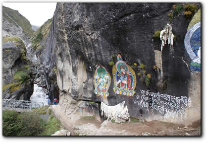
Mural Paintings along Renzola trek
2. Mera La 5413 & Mera High camp 5800m apprx(Did myself with one porter):
Mera la is extreme east of Everest base camp trek and actually falls in the Makalu Barun Natioanl Park.
I haven't tried for summiting Mera peak (6471m) but visited upto high camp from where it's about 4/5hrs upclimb. It's one of the easiest peaks.
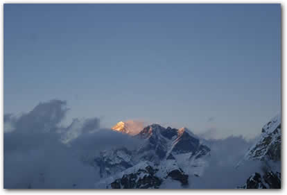
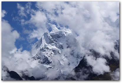
The views from High camp are awesome. One can see Cho Oyu 8201m to the extreme west, Everest 8848m and Lhotse 8516m in the middle, Makalu 8485m just to it's right and Kanchenjunga in the horizon hastyly hanging in the clouds. It looks very different from how it apprears in Sikkim/Darjeeling.
Burning Everest
I couldn't have recognized if I had not seen it from Everest summit in 2006 and it's adjacent peak "Mt Jannu/Khumbhakarna" which rises like sharp horn into the sky.
I would send a few more pics.. The pics are compressed images of original ones.
Best Regards,
Malli,
Other Pics:
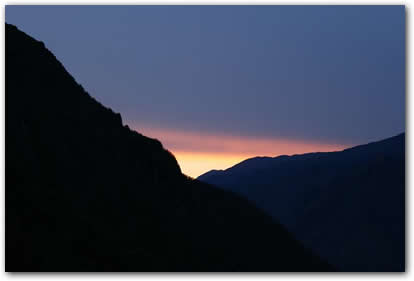
Sunset Chutanga on ridges
Sunset peaks Chutanga
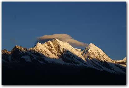
Mt. Kangteiga - A beautiful peak in the Everest Region
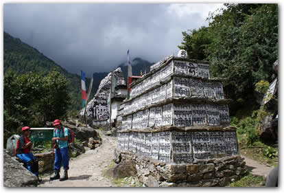
Mani carvings along everest trek
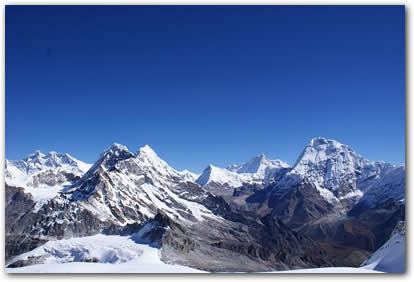
Stunning View of the Mountains 2
, |
| Total 29 vote(s). | | |
|
|
|
|
|
 | Messages/Opinions |
|
|
| | |
Click Here to login and post message
|
| Indian Alumni and Students from the following Indian and Global Institutes are invited to be members of 6bridges.com: |
| |
| India |
| Business & Accounting Institutes : FMS, ICAI, IIFT, IIM(A), IIM(B), IIM(C), IIM(I), IIM(K), IIM(L), IRMA(Anand), ISB, JBIMS, MDI(Gurgaon), NITIE, NMIMS, SJMSOM(IIT Bombay), SPJIMR, TISS, XIMB, XLRI |
| Technology Institutes : BIT(Mesra), BITS(Pilani), COE-Guindy(Anna Univ.), DCE, IISc, IIT(B), IIT(M), IIT(D), IIT(G), IIT(K), IIT(Kgp),IIT(Roorkee), ISI(Kolkatta), ISM (Dhanbad), IT-BHU, Jadavpur Univ., National Institutes of Technology(RECs), PSG(Coimbatore), RVCE(Bangalore), VJTI |
| |
| Global |
| Business, Technology & Accounting Universities/Institutes : AGSM(Sydney), AIM(Manila), Caltech, Carnegie Mellon, Columbia, Cornell, Dartmouth, Duke, Georgia Tech, Harvard, ICAEW(UK), IMD(Switzerland), INSEAD, Judge(Cambridge), London Business School, Manchester, Melbourne Business School, Michigan, MIT, Northwestern, NYU, Princeton, Purdue, Queen's(Canada), Said(Oxford), Stanford, U.Chicago, U.Penn, UC Berkeley, UCLA, Univ. of Illinois-Urbana, Univ. of Southern California, Univ. of Virginia, Warwick, Yale |
|
|